 By Bob Currie, Vessel Examiner
U S Coast Guard Auxiliary Station Galveston Flotilla.
Last week we discussed the Aids to Navigation (ATONs) that are part of the Lateral System, which marks the safe channel of navigable waterways. This week the discussion will be about the rest of the ATONs, also known as “Aids to Navigation with No Lateral Significance.” First we will review the ATONs with lateral significance.
The Station Galveston Flotilla of the US Coast Guard Auxiliary operates out of the USCG Station Galveston base on Galveston Island. They provide assistance to the Coast Guard by providing maritime observation patrols in Galveston Bay; by providing recreational boating vessel safety checks; and by working alongside Coast Guard members in maritime accident investigation, small boat training, watch standing, and procurement.
Red, Right, Returning: Lateral System ATONs Mark the Way
There are two basic types of ATONs. ATONs are either Lateral ATONs or Non-Lateral ATONs. Lateral ATONs are used to mark the preferred route to follow for well defined channels. They are part of the short-range system for navigating waterways called the U.S. Lateral System, or the U.S. Aids to Navigation System. In the U.S, short-range aids conform to the International Association of Lighthouse Authorities (IALA) Region B, otherwise known as System B. Most of Europe and Asia use System A. The main difference between the two systems is that our system, System B, uses the color red for buoys and beacons on the right side of the channel when viewed returning from sea (with green on the left), while System A uses green on the right and red on the left when returning from sea.
Lateral System Buoys
Buoys are aids that float on top of the water, but are moored to the bottom of the body of water. Some buoys have a light affixed to the top; some do not. A buoy with a cylindrical shape with a conical top is referred to as a “nun.” A buoy with a cylindrical shape and a flat top is referred to as a “can.”

Lateral System Beacons
Beacons are aids that are permanently fixed, most commonly to the bottom of a body of water. They may also be found on dry land. A beacon that has a light attached is simply referred to as a “light”; a beacon without a light is called a “daybeacon.”

Unlike buoys, which have their numbers and letters painted white, beacons have their numbers and letters painted the same color as the primary color of the beacon. Beacons that are numbered, just like buoys, mark the sides of the channel and provide the safe route. Neither buoy nor beacon numbers represent mile markers, but they are numbered sequentially for a particular route. Red daybeacons are always triangular, with a red light if lighted, while green daybeacons are always square, with a green light if lighted. The same even-odd system used by buoys applies to daybeacons that serve as lateral markers, that is, those markers that mark the sides of the navigable part of the channel.
Preferred Channel ATONs
Beacons and buoys that have horizontal bands of both red and green mark the junction of navigable channels. The top-most color indicates the direction of the preferred, or primary channel. When returning (entering a channel from the open sea or proceeding upstream), keeping the ATON with red as the top-most color on the right (starboard) side of the boat will place the boater in the preferred channel, while keeping those ATONs on the port side will place the boater in the secondary channel. If the top band is red, the ATON will be either a nun buoy or a triangular daybeacon. If the top band is green, the ATON will be either a square daybeacon or a can buoy. Red triangle or red light: go left; green square or green light: go right.

Safe Water Marks
Safe water marks indicate there is navigable water all around the mark. They usually mark fairways, mid channels, and offshore approach points. Safe water marks have red and white vertical stripes, are spherical in shape and are never numbered, but may be lettered with white letters on the red stripe. When a safe water mark is lighted or fitted with a sound signal, it displays a red spherical top mark. Lighted safe water marks show a white light with a Morse Code “A” rhythm (dot dash, or short long).

In the safe water mark diagram, the red sphere is not the light. The light is below the sphere. The light will flash one short and one long flash, with a period of darkness between the flash sequences. Those of us trained in Morse Code say “dit-dah” for “A.”
Isolated Danger Marks
Isolated danger marks are erected on, moored over, or placed immediately adjacent to an isolated danger that may be passed on all sides by mariners. They are black with one or more horizontal red bands and are fitted with a top mark of two black spheres, one above the other. When lighted the aid displays a white light, group flashing (two) with a period of 5 seconds. These aids should not be approached closely without special caution.
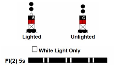
Naturally, it is important to discriminate between a safe water mark and an isolated danger mark at night. Does it flash short-long or does it flash short-short? Either way, the ATON description tells you that you can pass safely on either side. Just don’t pass too closely and you will be okay.
Special Marks
Special marks are not primarily intended to assist safe navigation, but more to indicate a special area or a feature referenced on charts or in another nautical publication. They may be used, for example, to mark anchorages, cable or pipeline areas, traffic separation schemes, military exercise zones, ocean data acquisition systems, etc. Special marks are colored a solid yellow and, when lighted, show yellow lights that are either fixed or with a slow-flashing rhythm. The slow-flashing rhythm is preferred. Many special marks are often private aids to navigation (PATONs).
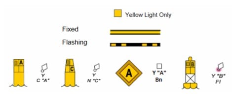
Note that although special marks are more often buoys, they can also be daybeacons as well, as shown in the figure. The little diagrams to the right of each of the special marks in the figure represent how the special mark will be indicated on a navigation chart. Special marks may be lettered, and when they are, the letters will be black.
INFORMATION AND REGULATORY MARKS
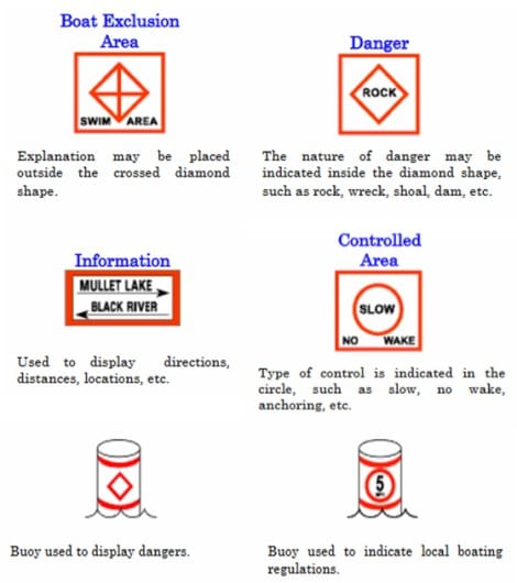
Information and regulatory marks are used to alert the mariner about various conditions or regulatory matters. One of the most common regulatory marks is the “No Wake” buoy. These marks have orange geometric shapes (rectangle, circle, or diamond) against a white background. When lighted will display a white light only. The light may be fixed or display any light rhythm not reserved for other types of aids.
Danger Buoys
A vertical open-faced diamond shape signifies danger. These buoys are often termed “Danger Buoys.” The nature of the danger is often indicated inside the diamond shape, such as Dam, Rock, Shoal, etc.
Exclusion Buoys
A vertical diamond shape with a cross centered within the diamond indicates that vessels are excluded from the marked area. These buoys are often called exclusion buoys. The explanation for the exclusion may be placed outside the crossed diamond shape, such as Exclusion Area, Dam, Rapids, Falls, etc.
Controlled Area Buoys
A circular shape indicates that certain operating restrictions or controls are in effect within the marked area. These buoys have various names, such as No Wake Buoy, Speed Buoy, Regulatory Buoy, Swim Buoy, Jim Bowie (just seeing if you are paying attention), etc. The type of control is shown within the circle. Other restrictions may be placed outside the circle.
Information Markers
A rectangular shape is used for displaying information such as directions, locations, distances, etc. They are more often daybeacons rather than buoys. Many are private aids.
Mooring Buoys
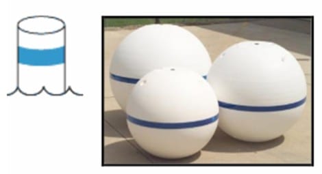
Mooring buoys are white with a blue horizontal band. This distinctive color scheme facilitates identification and helps the mariner distinguish these buoys from regular ATONs. That is an important distinction, because it is unlawful to tie up to an ATON. A mooring buoy is the one exception to the no tie up rule. When lighted, mooring buoys display a white light with any rhythm not reserved for other ATONs. Federal mooring buoys and those privately-owned buoys that are permitted as private aids to navigation, may be charted and listed in the Light List. Ball-shaped buoys are more common.
Summary
There are many aids to navigation other than those used to delineate the safe route of a waterway. The aids to navigation with no lateral significance include safe water marks, isolated danger marks, special marks, information and regulatory marks, and include mooring buoys. All ATONs help keep you safe or show you the way.
For more information on boating safety, please visit the Official Website of the U.S. Coast Guard’s Boating Safety Division at www.uscgboating.org. Questions about the US Coast Guard Auxiliary or our free Vessel Safety Check program may be directed to me at [email protected]. I am available to perform free Vessel Safety Checks, and I will come to your location to perform them. SAFE BOATING!
[9-9-2019]

 Posted in
