 By Bob Currie, Vessel Examiner
U. S. Coast Guard Auxiliary Station Galveston Flotilla
Many waterways have bridges that pass over them. Some are quite tall and are almost taken for granted, but many bridges are so low to the water that you need to know if you can safely pass beneath them. This column will address what you need to know about bridges.
The Station Galveston Flotilla of the US Coast Guard Auxiliary operates out of the USCG Station Galveston base on Galveston Island. They provide assistance to the Coast Guard by providing maritime observation patrols in Galveston Bay; by providing recreational boating vessel safety checks; and by working alongside Coast Guard members in maritime accident investigation, small boat training, watch standing, and procurement.
Low bridge, ev’rybody down
Low bridge, we’re coming to a town
You’ll always know your neighbor
And you’ll always know your pal
If you ever navigated on the Erie Canal
–Thomas Allen, The Erie Canal Song, 1905.
The Erie Canal, which runs for 363 miles from the Hudson River in Albany, New York, to Buffalo, New York, traditionally had bridges to navigate as well as 34 numbered locks to navigate. Barges and boats designed for navigation on the canal were quite low slung so they could routinely pass beneath the bridges, but passing beneath bridges is not generally a factor in modern boat manufacturing. You need to know what bridges you will pass under, what their vertical and horizontal clearances are, and whether you can safely pass beneath them, especially when navigating at night. Many boaters have failed to safely make the passage and suffered the consequences.
Know Your Boat
Ask most boaters what their boat draft is, and they will tell you one foot, two feet, etc. The answer they give to the question is their draft below the water line. How many of you know your boat’s draft above the water line? That’s what you need to know when approaching a low bridge. Sailboat operators know their air draft, as the draft above the waterline is known. If your boat’s instruction manual gives the boat’s dimensions, and it should, you need to make sure you consider any additions you make such as a T-top, tall fishing poles, antennas, or if you have your bimini top up. Also, when approaching a low bridge, you might want to let your passengers know, using the first line of the song stanza above, possibly. They may have to lower that long fishing rod to keep from breaking it.
Charting New Territory
No, this isn’t about the Lewis and Clark Expedition. It’s about using your chart to determine if there are any low bridges (relative to your boat’s air draft) you will be passing beneath. In our area of the Gulf Coast, low bridges are all over the place. We also have some lift bridges, and you need to know how to navigate those bridges if your air draft is a concern. You need to know how to read the chart in order to determine whether or not a bridge is considered a low bridge for your boat.
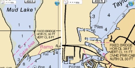
Let’s take the bridge over the entrance to Mud Lake, and the bridge over the entrance to Taylor Lake, both of which are popular fishing areas. If you look at the chart for Mud Lake, you see “FIXED BRIDGE, HOR CL 38 FT, VERT CL 8 FT.” That’s easy enough to figure out: it’s a fixed bridge, that is, not a swing bridge, lift bridge, etc.; the horizontal clearance is 38 feet, and the vertical clearance is 8 feet. But wait- is that clearance measured during low tide or high tide? If you look at most charts, all depths given are at MLLW (Mean Low Low Water). Mean Low Low Water is simply the lowest of the two low tides per day (or the one low tide) averaged over a 19-year period. But bridges are different. Their clearance is measured at MHW (Mean High Water). Mean High Water is the 19-year average of all the high water heights. To successfully use the MHW clearance for a bridge, you must know what the tide height is or will be at the time you wish to pass beneath the bridge.
Know Your Tides
A good tide app for your cell phone is invaluable when you want to cross under a potentially low bridge. If you look at the two tide charts, one is from Sunday, and the other is for 3 days ahead. A tide app that lets you look ahead will give you a good idea when it will be best to attempt to cross beneath a low bridge. Don’t forget that wave action can put you in danger if you just have enough clearance for a particular bridge, and don’t get trapped by a high tide if you have crossed beneath the bridge and need to do so again to get home.
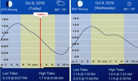
For example, if we use Mud Lake as an example, we would rather be able to pass beneath the bridge to that lake at high tide, as most of Mud Lake is only a foot deep at low tide. If we cross into Mud Lake at Low Tide, we want to be sure we can get back out at high tide.
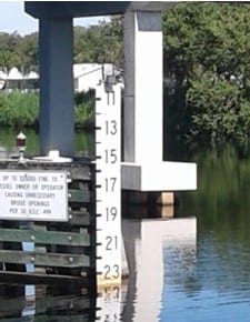
The information from the chart and from your tide app give you a rough estimate of the bridge clearance, and should be consulted the first time you navigate through a bridge span. Most bridges also have a clearance gauge attached to a bridge piling. Clearance gauges indicate the vertical distance between “low steel” of the bridge channel span, usually along the center of the channel, and the level of the water.
 If a bridge has navigation lights, a 360 degree green light will be found in the middle of the navigable portion of the channel, and red lights will mark the edges of the channel. A bridge with multiple spans may have only one span which can be navigated, or, like the Kemah Bridge, have more than one span that can be navigated. The Rules of the Road apply to bridges also, so keep to the right when using a single channel bridge, or use the right channel when there is more than one channel.
Manned Bridges
Many bridges must open to let taller boats through. Such bridges are manned during certain hours and open only upon request, while others, such as the railroad bridge between Galveston and Virginia Point are open continuously and only close to allow trains to cross. Always signal the bridge for an opening. Signals include horn blasts (usually a long and a short), but most boats call the bridge on their VHF/Marine radios. Bridges stand by on channel 9 or 13, depending on the location. Call the bridge by its official name to prevent confusion of other bridge operators. Names of bridges and proper VHF channels are found in updated guidebooks such as the Coast Pilot. The Coast Pilot version for our area is Coast Pilot 5. Be sure to follow the instructions of the bridge tender. When you reach a bridge, there may well be a crowd of boat traffic waiting their turn to go through the channel. For instance, the Kemah Bridge is open to inbound traffic for 30 minutes and then to outbound traffic for 30 minutes. As a boater, your job is to stay clear of the other boats that are trying to maintain position until it is there turn to go through. The safest place in the case of piled up traffic is at the end of the line. I have seen some bumping going on when waiting for our turn to go through the Kemah Bridge.
Summary
Sometimes the pathway to the open seas or to our favorite fishing spot contains bridges. Your job as a boat operator is to know if and when you can safely navigate through those bridges. That knowledge comes from checking navigational charts for bridge clearance at Mean High Water, checking a tide app for the height of the tide, and from knowing your air draft.
For more information on boating safety, please visit the Official Website of the U.S. Coast Guard’s Boating Safety Division at www.uscgboating.org. Questions about the US Coast Guard Auxiliary or our free Vessel Safety Check program may be directed to me at [email protected]. I am available to perform free Vessel Safety Checks, and I will come to your location to perform them. SAFE BOATING!
[10-7-2019]

 Posted in


