 By Bob Currie, Recreational Boating Safety Specialist
U. S. Coast Guard Auxiliary Station Galveston Flotilla
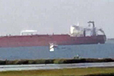
When you look at the surface of the water, especially the waters of the Houston Ship Channel and the different associated bays, unless you are very experienced in interpreting wave patterns you can’t tell how deep the water is in a particular location without using a depth finder. Oh, looking around can be quite deceiving. As in the picture below, the large ship is sitting in 42 feet of water just inside the ship channel. The white pleasure craft is sitting grounded in about two feet of water just a hundred yards away from the ship. Much of the water in our bays is quite shallow, and unless you know the area you are operating in, you are always in great danger of grounding your boat. This column will address grounding issues.
The Station Galveston Flotilla of the US Coast Guard Auxiliary operates out of the USCG Station Galveston base on Galveston Island. They aid the Coast Guard by providing maritime observation patrols in Galveston Bay; by providing recreational boating vessel safety checks; and by working alongside Coast Guard members in maritime accident investigation, small boat training, providing a safety zone, Aids to Navigation verification, in the galley, on the Coast Guard Drone Team and watch standing.

Pleasure Craft grounded off Bolivar North Jetty.
Photo by Edith Havard Watson, taken 09/05/21, used with permission.
One of the most important things you can do as a recreational boater is to know the territory in which you intend to operate. For Galveston Bay boaters, the number one hazard is shallow water. If you operate your boat in our bays, you are always either running in shallow water or running near shallow water. You can minimize the risk of grounding and damaging your boat by following a few rules. Here are some tips for boating in shallow water:
- Know your draft
- Know the reported depths where you intend to operate
- Know the local water hazards
- Know the effect of wind and tide on local water depths
- Slow down if you are unsure of the depth
- Don’t raise the trim all the way
- Watch for changes in the color of the water
- Don’t beach your boat on a falling tide
- Use GPS tracking
- Have a means of calling for help
Know Your Draft
A boat’s draft is the distance between the top of the waterline and the lowest point of the hull of the vessel. In other words, the draft measures how deep the vessel goes below the water’s surface. The draft determines how deep the water needs to be for the vessel to float freely. What is important to know about draft is that it isn’t something you can measure once and use that number for every occasion. Draft depends upon the load in the boat. If you measure your draft with one person aboard but then add a couple of passengers, you might find yourself grounded on a shoal if you depend upon that original draft measurement. If you are going to determine a general draft for your boat in order to estimate what depths you can safely operate in, be sure to measure the draft with the maximum allowed weight as stated by your capacity plate. This includes measuring your draft with a full gas tank. Also keep in mind that the depth measured by your depth finder is from the bottom of the transducer. That may be a couple of inches different from the bottom of your hull.
Know the Reported Depths
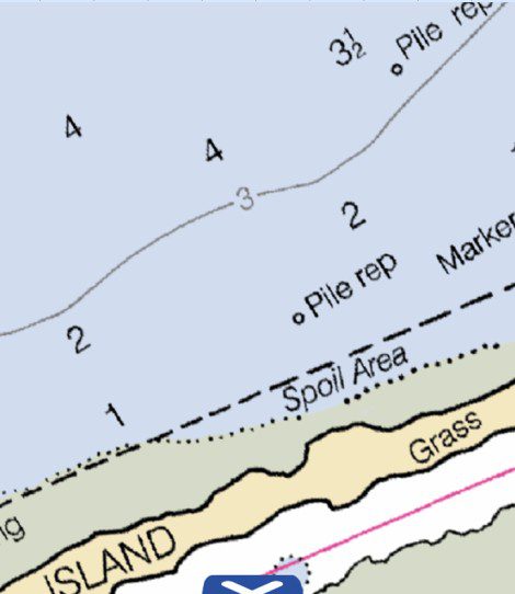
By “reported depths” I mean the depths as charted on paper charts or your GPS chart plotter. Many areas of our bays have navigational channels to help you. Stay within those channels and you will generally have no problems. Get outside those channels and you need to use the depth contour lines on your chart to stay in safe depth waters. The depth contour lines are solid lines with numbers representing the depth at mean lower low water for charts in our area. So if you see a contour line with a bunch of 7’s, you are likely to be quite safe running on that contour line, but if the contour line has a bunch of 1’s, you might not want to follow that line.

Chart showing a 3-foot depth contour line.
Know the Local Water Hazards
This is where a paper chart or GPS chart comes in handy. If you are going to operate in a new area, check the chart for hazards such as shoals, underwater pipes, and any other charted hazards such as sunken wrecks. I recommend using a GPS chart plotter to anyone who plans to operate in any of our Galveston bays. Review the hazards before venturing out onto the water, and keep in mind that wave action can temporarily lower the water depth and place you in danger of contacting underwater hazards that you normally would glide right over.
Know the Effect of Wind and Tide
We operate in tidal waters. That means that the depth can vary greatly with the tide. But the depth can be less on a high tide than it is on a low tide due to heavy winds emptying the bay. I have seen 300 feet of beach at high tide and 10 feet of beach at low tide, all because the wind was blowing the water out or blowing it in. You can walk across the eastern portion of East Bay when the wind blows the water out. The chart depths are only a starting point for deciding where you can operate. NOAA charts say at what point the average depths are measured. Usually the depths given were taken at “mean lower low water.” This is an average of tide levels over a period of years. If you find yourself run aground, knowing the tide and wind activity can help you decide how you are going to get free. For instance, if the tide is rising, you may want to sit back and relax until the water level rises enough to float you free. If the tide is falling, you may want to take measures to free your boat as soon as possible before the situation becomes worse. This means you may have to get out and push. Be sure to have footwear that will keep you from getting your feet cut on oyster shells. Also, check your boat for leaks before attempting to unground it. You may find yourself sinking instead of floating once you get the boat to deeper water.
Slow Down If Unsure of the Depth
While it is true that slowing down will increase the amount of depth you will need, if you run aground slowly the danger is minimal and you will have a better chance of getting back to deeper water. If you ground at high speed you can severely damage your boat and possibly eject you and your passengers, causing injury or even death. You will also have a much harder time refloating your boat than you would if you barely grounded. If you are familiar with the water, however, and know for sure that you have enough depth to accommodate your running draft while on plane, it is not unreasonable to keep the boat on plane to get across the shallows.
Do Not Raise the Trim All the Way
The instinct is to raise your trim to protect your engine when running in shallow water. While you can certainly raise the trim a little, do not raise it all the way. If you run aground with the trim all the way up, you eliminate the engine as a means of getting back to deeper water. If you run aground with some trim left, then raise the engine up that last bit to help get back to deeper water.
Watch for Changes in the Color of the Water
Channels and deeper waters often appear dark in color, while sandy shoals look light spots in the water. That said, color changes can also fool you. The water over shallow weed beds can look much darker than the surrounding water. It is best to avoid any sort of color changes while running unless you know what is below the water from experience or by chart.
Don’t Beach on a Falling Tide
The water depths approaching our beaches change very, very gradually. If you like to beach your boat in order to get out and wade or fish from the bank, don’t do this if the tide is falling. You could find the water has completely disappeared leaving your boat high and dry when the tide is falling. This is a good time to mention that you should have a good supply of drinking water and food just in case something like this happens.
Use GPS Tracking
One of the neatest functions of GPS chart plotters is the Tracking function. As you move through the water, your GPS tracks where you have been, leaving a nice line that you can follow to back track or to use in the future to get into areas where there is a narrow channel that runs through very shallow water. For instance, Rollover Pass, until they filled it in, had some very good fishing that you could access by boat if, and only if, you knew the exact location of the very narrow channel that used to lead from the Intracoastal Waterway to the pass. These channels are invisible on the surface. In some places the channel was so narrow that two boats could barely meet. I found that out when I made a wide swing to get around a friend who was anchored in the channel and fishing. I had to get out and push after I grounded. After that I made sure I didn’t deviate from the track on my GPS.
Have a Means of Calling for Help
I am a big proponent of having a marine VHF/FM radio aboard. The radio isn’t just for emergencies. The Coast Guard issues important marine information bulletins via channel 16 (Coast Guard) and Channel 13 (Vessel Traffic Services). You should monitor both channels using the Scan function of your radio. If you should find yourself aground, then you have a method of getting help using channel 16 to call the Coast Guard. Grounding isn’t an emergency in most cases. It is only if you are in danger of sinking or someone needs emergency medical help that you should make a Mayday call. Otherwise, just call the Coast Guard and request assistance. If you have towing insurance, and I highly recommend that you obtain that, simply call the tow operator via channel 16. Both BoatUS and SeaTow monitor channel 16. While you could possibly be out of range of the towing company radios, if you are operating within 20 miles of shore you will always be in range of the Coast Guard radio, and they can make the call to your towing company of choice. A good second option is to have a cell phone as a backup.
Intentional Grounding
While it is enjoyable to fly across the water at cruising speeds, you might want to consider operating at lower speeds when near shore. That is where you are more likely to encounter objects floating in the water. Some of those floating objects are large enough to do substantial damage to your boat, including breaching the hull. If you find your boat is taking on water at a rate at which the bilge pump cannot keep up, one alternative to save your boat is to intentionally ground it to save it from sinking. A commercial recovery company can then refloat your boat and get it to a repair facility.
Summary
In our local area, Galveston bays can be quite shallow and operating within them requires some finesse. By following a few tips you can safely navigate those shallow waters.
For more information on boating safety, please visit the Official Website of the U.S. Coast Guard’s Boating Safety Division at www.uscgboating.org. Questions about the US Coast Guard Auxiliary or our free Vessel Safety Check program may be directed to me at [email protected]. SAFE BOATING!
[Sept-7-2021]

 Posted in


Thank you for this vital information. Carlis Cole