 By Bob Currie, Recreational Boating Safety Specialist
U. S. Coast Guard Auxiliary Station Galveston Flotilla
When I bought my first powerboat some 40+ years ago, it was well-equipped (for the time) for safety and navigation, having a compass on the console. That’s about all that was available for recreational boats back then. Since then, GPS has become quite affordable for recreational boaters, and radar units are well within the affordability for those who venture far out to sea in their quest for big fish.
The Station Galveston Flotilla of the US Coast Guard Auxiliary operates out of the USCG Station Galveston base on Galveston Island. They aid the Coast Guard by providing maritime observation patrols in Galveston Bay; by providing recreational boating vessel safety checks; and by working alongside Coast Guard members in maritime accident investigation, small boat training, providing a safety zone, Aids to Navigation verification, in the galley, and watch standing.
While radar is great, it can be difficult to interpret for the average boater. It requires changing the settings for different conditions, and identifying objects can be quite a challenge. So, if you want to have a better idea of what is out there on the water, consider using AIS: the maritime Automated Identity System (also known as Automatic Identification System).
History of AIS Tracking
AIS was developed in the 1990s as a high intensity, short range identification and tracking system. The United States began developing AIS in response to the Exxon Valdez oil spill in Alaska. Congress passed the Oil Pollution Act, which required the US Coast Guard to “develop a vessel tracking system for tankers going to Alaska.” The new system had to be autonomous (not requiring input from an operator), continuous, and digital. It had to automatically communicate and portray a ship’s location to other ships and to shore-based Vessel Traffic Services without risk of human error. If you think this sounds like an airplane’s trans ponder, you would be right.
The Coast Guard decided to use VHF (very high frequency) radio for their tracking system. While the Coast Guard was developing a ship tracking system, the British were also testing a VHF-based tracking system. In the mid-1990s the International Telecommunications Union (ITU) and the International Maritime Organization (IMO) combined their efforts to create a single system that could be used worldwide. Although originally designed to be used between ships and between ships and shoreside locations, in 2008 companies and government programs deployed low orbit satellites with AIS receivers on them. The combination of terrestrial and satellite AIS has resulted in a global tracking system that is available to anyone. I have an AIS receiver app on my cell phone.
Collision Avoidance
AIS was originally created to supplement marine radar tracking for collision avoidance and to help provide safer navigation at sea. AIS is an automatic tracking system used onboard ships and most commercial vessels over certain lengths. The link to the US Coast Guard regulations is: https://www.navcen.uscg.gov/?pageName=AISRequirementsRev. Although developed for collision avoidance, it is now the primary method for tracking ships around the world.
Types of AIS Devices
AIS Class A is mandated by the US Coast Guard for most commercial shipping and passenger vessels on coastal waters in the US, international voyages, and even on the Great Lakes. AIS position information is transmitted every few seconds by each ship. Other less critical information, such as the ship’s name is generally transmitted once every 6 minutes. AIS information may include:
- MMSI Number
- Navigation Status
- Rate of Turn
- Speed over Ground
- Position Accuracy
- Latitude and Longitude
- Course over Ground
- True Heading
- Time Stamp
- IMO Number
- Radio Call Sign
- Vessel Name
- Type of Ship
- Dimensions
- Location of ship where Latitude and Longitude are referenced
- Draft
- Destination
- ETA
Recreational boaters can optionally install an AIS transmit/receive system (AIS Class-B) intended for recreational boats. The signaling in Class A and Class B systems differ, as potentially, many more AIS Class B transmitters can exist, as well – there are more recreational boats than ships. The Class B signaling is designed to limit congestion on the VHF channels dedicated for its use.
AIS is not required for pleasure boaters, however the private boat owner can purchase an AIS receive-only system that can pick up the AIS Class-A information transmitted by the ship. This provides important safety information if you boat in an area of shipping, since you will know each ship’s destination, course, and speed. That information can be used to help the boater stay clear of any shipping. The downside is that a receive-only unit does not provide the ships you encounter any knowledge of your existence on the water. A receive-only unit will allow you to “dodge” any commercial vessels, and that is a big plus.
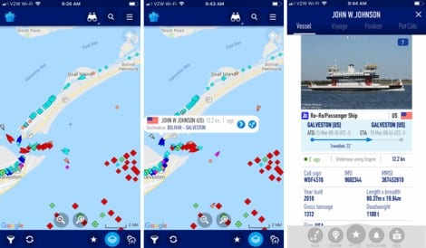
A fourth option for recreational boaters who need to navigate the ship channel but do not need it for long range navigation is to use a cell phone app such as Marine Traffic. The downside to this is that you are limited to the range of the nearest cell phone tower. The app won’t work if you get out of range of a cell phone tower. The app provides a snapshot in time and doesn’t update continuously like an AIS would, but it does give you a good overview of traffic in your area. Note that such an app provides you with the full Class A AIS information by clicking on a ship icon. I use it to track the ferries. The dark blue icon is a ferry about to dock at Bolivar. Clicking on the icon would tell me which ferry it was. In this case it was the John W Johnson.
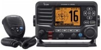 Some marine radios have built-in AIS, such as this Icom radio.
The AIS models that I have used are integrated into the GPS screen. We call such a system an overlay, as you will see the AIS-equipped vessels overlaid on your GPS screen.  This is quite convenient as you only must look at one screen when navigating.
Summary
If you operate your boat in close proximity to shipping traffic, you may want to invest in either a Class B AIS (automatic identification system) or an AIS receiver for your boat. It is much cheaper than radar and much easier to use. If you don’t plan to go out of cell phone range from shore, you may find a cell phone app AIS service quite useful.
For more information on boating safety, please visit the Official Website of the U.S. Coast Guard’s Boating Safety Division at www.uscgboating.org. Questions about the US Coast Guard Auxiliary or our free Vessel Safety Check program may be directed to me at [email protected]. I am available to perform free Vessel Safety Checks, and I will come to your location to perform them. SAFE BOATING!
[March-16-2020]

 Posted in


